|
|
|
|
Geology
Find out more
The geology of the Isle of Wight is very variable, with strong influences on the landscape. Most remarkable are the fossils, especially dinosaurs, found on the Island.Habitat Action Plans
Maritime
Cliffs and Slopes HAP (2002)
External links
Dinosaur Isle
A
Brief History of Dinosaur Collecting on the Isle of Wight
Rockwatch
Geology of Britain viewer
Rocks and fossils of the Isle of Wight
The oldest
rocks visible on the Island which contain the bones of reptiles, including
the famous dinosaurs, were laid down about 110 million years ago when the English
Channel and much of southern England formed part of the valley of a large river.
The Island's dinosaurs come from the Wessex formation, which dates from between
125 and 110 million years ago. During this time the Isle of Wight, then located
on a latitude at which North Africa resides today, had a subtropical environment,
and was part of a large river valley complex, which ran along the south coast
of England to Belgium. 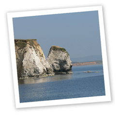 A world of ponds, rivers and swamps, and so had conditions
favourable for the formation of fossils. Animal remains from this time include
crocodiles, turtles, pterosaurs, mammals and possibly some birds. In the water
were snails, fish and mussels. As this environment did not change much over
the course of 10 million years, a large number of fossils were formed, and
so the island today has many of them. There are around 15 species of dinosaur
currently recognised from the Isle of Wight.
A world of ponds, rivers and swamps, and so had conditions
favourable for the formation of fossils. Animal remains from this time include
crocodiles, turtles, pterosaurs, mammals and possibly some birds. In the water
were snails, fish and mussels. As this environment did not change much over
the course of 10 million years, a large number of fossils were formed, and
so the island today has many of them. There are around 15 species of dinosaur
currently recognised from the Isle of Wight.
The area sank lower, and the sea covered the land, laying down deposits of sands and clay, and then chalk. Chalk is made from the fossilised skeletons of microscopic planktonic algae which lived in the sea. Over millions of years the slow accumulation of their remains built up the layers of chalk that can be seen in the downs and cliffs of the Isle of Wight, and these layers contain fossils of other species which lived in the seas at that time, such as ammonites and sponges.
 About 70 million years ago the sea bed rose once more, and eroded away until it was covered by a shallow sea again. More sand and clay was laid down, and these can be seen at Alum Bay, in the famous multi-coloured sands. This sea silted up and the area was covered by lagoons and marshes. At this time, about 40 million years ago, the climate of the Island was sub-tropical and animals such as crocodiles and turtles lived there - their fossilised remains can still be commonly found on the northern coast of the Island, for example on the sands at Fort Victoria.
Some 30 million years ago the rock layers rose up again and eroded to form the present shape of the Island, although it remained attached to the mainland. To the north, roughly where the present Solent runs, was a river known as the Solent River which drained a large area of what is now central southern England. About ten thousand years ago, when glaciers covering the north of Britain melted at the end of the last ice age, two things happened to create the Solent. Firstly, a great amount of flood water ran into the Solent River and its tributaries, carving the estuary deeper. Secondly, post-glacial rebound after the removal of the weight of ice over Scotland caused the island of Great Britain to tilt about an east-west axis. Over thousands of years, the land sank in the south (a process still continuing) to submerge many valleys including the Solent. The estuary of the Solent River was gradually flooded, and eventually the Isle of Wight became separated from the mainland as the chalk ridge between The Needles on the Island and Old Harry Rocks on the mainland was eroded. This is thought to have happened about 7,000 years ago.
| home | partnership | habitats | species | biodiversity opportunity areas | benefits of biodiversity |
biodiversity & you | advice | walks & events | library | contact |