|
|
|
|
Find out more
The Isle of Wight is defined by its coastline - the influence of the sea is felt everywhere. From the sheltered mudflats, sand dunes and saltmarshes of the north coast to the rich soft cliffs of the south-west; all are important habitats.
Sea Caves
Rocky Shores and Reefs
Maritime Cliffs and Slopes
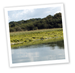
Saltmarsh
Sand Dunes
Coastal Saline Lagoons
Intertidal Flats
Seagrass Beds
Estuaries
Buglife
Solent Seagrass Project
Estuaries Project
Habitat Action Plans
Maritime
Cliffs and Slopes HAP (revised 2007)
Solent
Coastal HAP (2004)
including the national Priority Habitats Saltmarsh, Mudflats, Coastal Vegetated shingle, Coastal Sand Dunes and Saline Lagoons.
Targets
Overview of targets
The north coast of the Island is dominated by sheltered mudflats and muddy gravels, with areas of saltmarsh within estuaries, vegetated shingle, sand dunes and saline lagoons. Our 160ha of saltmarshes are amongst the best in the Solent but they are at risk from sea level rise and hence are likely to be in long-term decline. The south coast of the Island is dominated by 51km of actively eroding cliffs and chines of great biodiversity and geological importance, they also support nationally important populations of invertebrates. They are not threatened as a habitat but in some places, erosion is so rapid that vegetation fails to become established and their biodiversity value can be reduced.
Estuaries are complex and highly productive ecosystems supporting a wide range of habitats and species. They extend from the river’s upper tidal limit to the sea and form a constantly changing environment where freshwater and marine systems interact.
 Traditionally places of human settlement, estuaries provided sheltered harbours, transport and trade routes and the natural resources for industry. Such history provides a backdrop of rich cultural and maritime heritage for today’s activities supporting a wide range of activities including recreation, transport and industry. This, together with their ecological importance, can often result in conflicting interests and the need for management.
There are a range of organisations with statutory responsibilities on land, sea and across the intertidal zone and each has different priorities. In addition, an increasing number of national and international designations, policy and byelaws make management of the estuary as a whole very complicated.
The Estuaries Project was set up in the late 1990s with the aim of promoting and co-ordinating the sustainable integrated use of the Island’s estuaries, and developing understanding of estuarine features and processes. It is a partnership working primarily on the Medina and Western Yar estuaries, and is actively involved in projects that raise awareness of estuaries, their habitats and associated species.
Over the last ten years, the project has attracted significant funding for local projects including monitoring and research, interpretation, access improvements to appropriate sites and signage for sensitive areas. The project has also instigated bird surveys, saltmarsh monitoring and a series of tools for the Medina estuary that will help to assess the potential impact of development.
Saltmarshes are distributed along the Solent coastline within comparatively small estuaries. They form a key component of the Solent and Southampton Waters SPA and candidate Maritime SAC. 80% of the Island resource is concentrated in two sites, at the estuary of the Western Yar and at Newtown. The Medina and East Yar estuaries in contrast have lost much of their semi-natural saltmarshes to reclamation, increasing demand for recreational boating facilities, development of water-side industries and homes, and the natural processes of erosion leading to coastal squeeze.
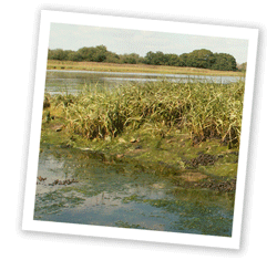 Mixed saltmarsh is a particularly valuable resource and those in the Solent are notable for their concentration of nationally scarce flowering plant species. Although saltmarshes in the Solent are considered to be generally of recent origin (less than 120 years old), some on the Island, principally in parts of the Newtown estuary, are believed to be much older, and they are not dominated by cord grass. However, the 17 has which have developed at Newtown since the breach of the sea wall in 1954 are more typical of the cord grass swards of the Solent coast.
The Island’s saltmarshes contribute to the international importance of the Solent as an important resource for wading birds and wildfowl. They act as high tide refuges for birds feeding on adjacent mudflats, as breeding sites for waders and gulls and as a source of food for passerine birds particularly in autumn and winter. In winter they may also be used as feeding grounds for Brent goose, teal and wigeon. Areas with high structural and plant diversity, particularly where freshwater seepages provide a transition from fresh to brackish conditions, can be important for invertebrates. The intimate relationship between saltmarsh vegetation and other coastal habitats such as shingle structures, sand dunes and intertidal flats means that they need to be considered as a functional unit.
Sand Dunes
Sand dunes provide a unique habitat for a rich community of highly specialised plant and animal species. St Helen’s Duver is the best local example; it supports the richest concentration of flowering plants per area of anywhere on the Island. Plant species associated with sandy soils are currently (2000) showing increases in numbers and distribution. Sea buckthorn dune scrub is present on the spit dunes at the entrance to Bembridge Harbour.
Intertidal flats
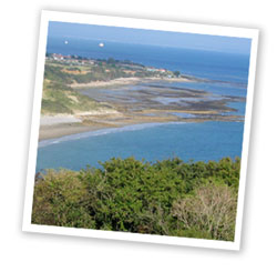
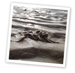 The largest extent of intertidal flats in the Solent is found along the sheltered north-eastern shore of the Island between Fishbourne and Horestone Point, and this is the only major zone of sediment accumulation within the coastal cell stretching from Selsey Bill to Portland. At low tide a wide range of sediments are exposed along this stretch of coastline including the fine estuary muds at Wootton Creek, cobbles and boulders at Pelhamfield and extensive sandflats at Ryde which reach a maximum width of almost 2km.
The intertidal flats can be characterised in terms of their benthic fauna. Holme and Bishop (1980) split the sedimentary shore communities of the Solent and Southampton Water into five main types: crustacean-polychaete, sandmason worm, lugworm, carpet shell and furrow shell. They are extremely productive biologically and have an abundance of organisms, but low diversity with few rare species. They are important nursery areas for flatfish, and they are able to support internationally important populations of wildfowl and waders as winter feeding grounds. Typically, twelve species of wildfowl and twenty species of wader regularly use the Island’s estuaries.
Sheltered muddy gravel habitats can be extremely species rich, especially in fully marine conditions, because the complex nature of the substratum supports a high diversity of both infauna and epifauna.
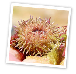
Saline lagoons
Saline lagoons are a nationally rare habitat, largely confined to the south and east coasts of England, where they are relatively transient features. There are only a limited number of species able to tolerate the extreme conditions found within them; but they include a significant number of specialists which are not, or rarely, found elsewhere. Lagoons possess a characteristic invertebrate fauna that shows little regional variation, even within Europe. In Britain, several of these species are very rare and are protected under the Wildlife and Countryside Act 1981. These include the starlet sea anemone in its type locality, Bembridge Harbour lagoon, and a lagoonal worm.
True lagoons support only three types of aquatic vegetation – stands of green algae, sea-grasses and similar plants, and occasionally stoneworts. The foxtail stonewort, which occurs in the Bembridge Harbour lagoon, is protected under the Wildlife and Countryside Act 1981. However, much of the area of lagoon beds is bare sediment, devoid of vegetation.
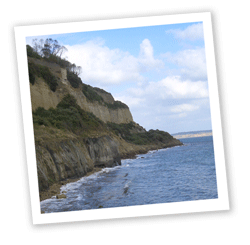
Maritime cliffs and slopes
The sea cliff habitat extends inland along the inner greensand cliff above the Undercliff at the south of the Island, which is itself a large, ancient pre-existing landslide complex. The inner cliffs support some of the best Island examples of maritime hard cliff vegetation, principally at the western end of this exposure. The habitats which develop on the cliffs and slopes are particularly varied, dependent upon soil type, ground stability and water source. There is generally a high proportion of bare ground compared with other semi-natural habitats. The vegetation forms a transition from maritime species to terrestrial communities further inland. In addition, soft cliffs on sheltered parts of the coast can develop undercliff vegetation of woodland, scrub, tall herb and rank grassland. There is an unusual example of a perched dune on the cliff top at Chale.
Maritime cliffs are formed at the junction between the land and the sea where a break in slope is formed by slippage and/or erosion by the sea. The slopes formed range from shallow to vertical and vary in height and geology. Soft rock cliffs are characterised by slips, seepages and areas of slumped cliff face that gradually become vegetated. Chalk cliffs are characterised by sheer faces with small, but important, plant communities and ledges that can provide important nesting sites for seabirds. Exposure to wind and salt spray, together with geology, is one of the key determinants of the vegetation type which develops along maritime cliffs.
The sea cliffs and slopes frequently support rich and specialised plant and animal communities, many on the northern limit of their range. The combination of friable soils, hot substrates and open conditions maintained by cliff slippages offer a continuity of otherwise very restricted microhabitats and these support many rare invertebrates which are confined to such sites.
 Soft Cliffs
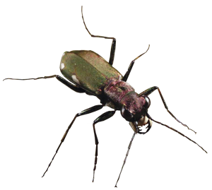
Survey work in 2008 by Buglife, Invertebrate Conservation Trust, demonstrated that the Island’s soft cliffs are some of the UK’s richest. Coastal soft rock cliffs are one of our most spectacular wildlife habitats. They are home to incredible insects such as the handsome cliff tiger beetle (left), long-horned mining bee, chestnut click beetle and the Glanville fritillary - the Island’s special butterfly.
Soft cliffs are prone to frequent slumps and landslips and to erosion by the sea, weather and groundwater seeping though the rocks. These natural processes create a changing mosaic of habitats with areas of bare ground which warm up rapidly in the sun, clumps of flowery vegetation, wet hollows and streams – all ideal for mini-beasts.
If these processes are prevented or reduced through coastal protection then local extinctions of these specialised insects will follow. Other threats to soft cliffs are intensive management, artificial drainage and climate change.
Seepages, springs and pools provide the wet muds required by many species of solitary bees and wasps for nest building, and also provide suitable conditions for a rich assemblage of other invertebrates and rare plants. Ponds, which can be transient in nature, are important for breeding amphibia. Chalk cliffs at the eastern and western extremities hold significant populations of breeding seabirds. Cliffs are also important as geomorphological features and for their geological exposures.
Sea caves, rocky shores and reefs
Rocky shores and reefs are found where resistant rocks occur at the coast. Littoral rock (between mean high water springs and mean low water springs) is found at Bembridge, along the boulder shore associated with the landslip zone and the ironstone reefs at Hanover Point. In some areas, these rocks extend into the sublittoral zone and form rocky reefs which fringe the coastline, particularly adjacent to hard cliffs, where limestone outcrops at Bembridge and chalk outcrops at Culver Cliff and the Needles. Sea caves are also found in these stretches of coast, but they are largely inaccessible.
 The range of chalk intertidal, cliff and cave habitats off the Island’s coast create a diverse range of habitats and communities which are of international nature conservation importance. The chalk cliffs at Culver and Freshwater Bay to Alum Bay display rare chalk cliff algal communities ranked as being respectively fourth and fifth most important in the country. The Island’s offshore seabed includes some of the most important sub-tidal British chalk reefs, representing over five percent of Europe’s coastal chalk exposures. The undisturbed cobble and boulder shore in the Yar estuary has important communities associated with wave-sheltered, current-swept reefs.
The geographical location of the Island, at the boundary between the warmer waters of the western channel and the cooler waters from the east, provides a transition between the warm-temperate (Boreal-Lusitanian) and cold-temperate (Boreal) provinces. Consequently the diversity of the Island’s marine life is increased by the presence of species on the edge of their range. In recent years, sea temperatures have been warmer and some local fish species such as gilthead bream, bass and red mullet have increased in number and extended their range eastwards to the North Sea. Purple topshells were rare before 2002 and known only as far east as Bembridge, but by 2009 they had become much more abundant and were spreading to the Sussex and Kent coasts.
In addition to the reefs derived from bedrock, biological reefs can form as a result of the activities of reef-building creatures. A small polychaete worm Sabellaria spinulosa forms aggregations of tubes which form solid but fragile structures, several centimetres thick and raised above the seabed. They are built over areas which are predominantly sediment and they persist for many years. Once these reefs have formed, other species can move and colonise them.
Key Sites
Bembridge Ledges
St Helens Ledges
Freshwater Bay
Horse Ledge and Yellow Ledge
Shanklin
Ventnor Bay
Castlehaven
Culver Cliff
The Needles Headland
Offshore
In 2009, Natural England cited the waters off the Island as being among the richest in the UK. Some highlights around our coastline include the pupping grounds for several species of shark including the rare porbeagle and the thresher; the electric ray is also found here. In our marine caves, dead men’s fingers - a soft coral-like sponge can be found and our underwater chalk reefs are home to a colourful garden of red algae and anemones such as the snakelock and jewel anemones.
The waters of around the Island have proved hazardous to shipping over the centuries and there are many wrecks around the coast. From a biological point of view, these are artificial reefs and provide another habitat for marine life to colonise over time. Details of the positions of wrecks can be found on www.pastscape.org.uk
Seagrass beds
Intertidal sediments along the north coast of the Island also support beds of seagrass and dwarf seagrass which extend below mean low water. Both species are nationally scarce. Extensive seagrass beds are highly productive because organic material released from decaying grass provides an important nutrient source for marine ecosystems. The plants themselves provide attachment for invertebrates and algae and the stabilised substrate can support a rich infauna.
Extensive beds can provide important nursery and feeding grounds for a variety of juvenile fish. Intertidal beds are a vital food source for brent geese and wigeon. There are extensive seagrass beds at Ryde Sands, Osborne Bay, East Cowes, Thorness Bay, west of Yarmouth and at Totland Bay
Solent Seagrass Project
Seagrasses, also called eelgrasses, are unique, being the only flowering plants able to thrive in salt water and form underwater meadows – an important habitat for juvenile fish and seahorses.
Following outbreaks of disease and damage from human activities seagrasses are now considered nationally scarce and are a priority habitat. The Island, with its shallow, sandy sheltered bays, provides a perfect habitat for seagrass and is home to some of the UK’s most important seagrass meadows.
The Solent Seagrass Project has been running for four years, surveying and collecting records of seagrass. Many areas have been identified but the mapping work will continue to gain a better understanding of the total seagrass extent. Such data is incorporated into local management and conservation plans to help protect these important habitats.
| home | partnership | habitats | species | biodiversity opportunity areas | benefits of biodiversity |
biodiversity & you | advice | walks & events | library | contact |